
價格:免費
更新日期:2019-03-19
檔案大小:5.8M
目前版本:6.5
版本需求:Android 4.4 以上版本
官方網站:http://www.lanase.unam.mx/es/
Email:mcrangelheras@gmail.com
聯絡地址:Antigua Carretera a Pátzcuaro 8701 Ex hacienda de San José de la Huerta, Morelia, Michoacán, México

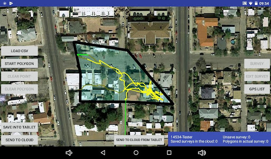
Woodfuel Collection Tracker was designed to integrate data from Columbus v990 GPS trackers with semi-structured field surveys to quantify the time effort and places visited by peasants in collecting firewood across the landscape.
People need to carry the GPS unit wherever they go during their daily activities, for a period determined by the local conditions and research question.
Every 3 to 5 days, tracks recorded by Columbus v990 GPS trackers are loaded into a widescreen tablet and display over a google maps satellite image.

A concise multiple-choice interview is conducted to recognize what the person wearing the GPS unit was doing at various times and places along the recorded track. Places where people did some work (e.g. collected firewood, graze, work in the crops) are saved as polygons drawn over the screen by the interviewer.
Depending on internet connectivity, data is saved into the tablet or send to the cloud to be analyzed remotely in almost real time.
Spatial and temporal descriptive statistics regarding tracks and people’s activities are calculated automatically.

Please email comments and suggestions to aghilardi@ciga.unam.mx
Version 1.0
Developer: Roberto Rangel Heras
Special thanks
Adrián Ghilardi, Rob Bailis, Tupalishe Ghambi.
LANASE, UNAM & SEI
